The AGS Globe: Mapping the Cradle of Civilization: How Geography Shaped the Indus Valley
The American Geographical Society's Weekly Newsletter for June 17, 2025
We hope you have enjoyed the first issues of our new weekly, the AGS Globe. The Globe aims to inform and inspire the public with articles about the realms of geography and geospatial as well as exciting opportunities and news from our network. Our pieces fall under four categories: Exploring the World, Championing Geography, Mapping the News, and EthicalGEO. As the world revolves, geography evolves. The mission of the AGS Globe is to bring our storied legacy of exploration and thought leadership into the frontiers of the future.
Mapping the Cradle of Civilization: How Geography Shaped the Indus Valley
When we think of ancient civilizations, iconic structures like the pyramids of Egypt or the ziggurats of Mesopotamia often come to mind. Yet, nestled in the northwestern region of South Asia was another ancient marvel: the Indus River Valley Civilization (2500 to 1700 BCE). Also known as the Harappan Civilization, the Indus River Valley Civilization stood alongside Egypt and Mesopotamia as one of the three earliest and most expansive urban cultures in human history.
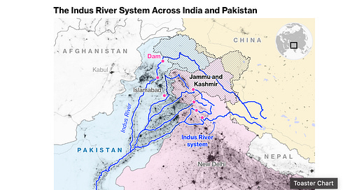
The Indus River played a crucial role in transforming the dry plains into thriving cities. Originating high in the Tibetan Plateau near Mount Kailash, the river flows nearly 1,900 miles (3,050 kilometers) southwest before joining the Arabian Sea, located in the northern part of the Indian Ocean. The annual flow of the Indus River is approximately 7.3 trillion cubic feet (207 billion cubic meters) and it relies heavily on glaciers and snow from the Himalayas, Karakoram, and Hindu Kush ranges in Tibet, Afghanistan and northern Pakistan.

The Indus River and its major tributaries sustain one of the most densely populated and agriculturally productive regions on Earth, with more than 268 million people residing in the river basin. It serves as a vital source of water for drinking, energy production, household use, and irrigation across the region. Nearly 90% of Pakistan's population resides within the Indus Basin. Approximately a third of Pakistan’s hydropower and 80% of its agriculture rely on the Indus River. While the basin faces climate-related disasters and cross-border tensions, it also holds potential for cooperation and shared prosperity.
The river has shaped the geography, culture, and economy of the region for millennia, particularly during the height of the Indus Valley Civilization. Its fertile floodplains supported agriculture and nearby resources such as timber, metals, and precious stones fueled the growth of major cities like Harappa and Mohenjo-daro.
Centuries later, the Indus River became a geopolitical focal point once again. When India gained independence from British rule in 1947, a boundary was drawn between India and Pakistan across the Indus River basin. Two major irrigation headworks ended up on the Indian side, while their canal networks flowed into Pakistan, leading to disputes over water access. To resolve these tensions, the Indus Waters Treaty was signed in 1960 in Karachi. The treaty divided the Indus River system: Eastern rivers (Beas, Ravi, and Sutlej), allocated to India, and the Western rivers (Indus, Jhelum, and Chenab), allocated to Pakistan.
However, the stability of the treaty has recently come into question. In April 2025, following the militant attack in Pahalgam in Indian-administered Kashmir that killed 26 people, India announced the suspension of its participation in the Indus Waters Treaty. Suspending their participation in the treaty grants India greater control over the flow of the Western rivers, which is expected to have significant implications for Pakistan’s water supply. A Pakistani report notes a 13.3% drop in Indus water supply to Punjab farms after India suspended the treaty. The move is seen as a major shift in regional water diplomacy and worsened the fragile Indo-Pakistan relationship.
The Indus River, once the cradle of a great ancient civilization, remains central to the region’s identity and survival. From historical achievements to present-day challenges, its waters continue to carry the weight of culture, economy, and diplomacy, reminding us that rivers are not just natural resources, but lifelines that shape the fate of nations.
Sources:
Associated Press of Pakistan. (2025). UN rights chief urges Pakistan & India to uphold ceasefire, restore water-sharing treaty.
BBC News. (2022). Partition: Why was British India divided 75 years ago?
Dubey, Y. (2024). Tracing the Lifeline of Civilization: Know Everything About the Indus River. Amargranth.
Editor, V. (2025). Indus Water Treaty 1960, Map, Key Features, Timeline, Pahalgam Attack. Vajiram & Ravi.
Krishna, R. (2024). Indus River. EBSCO.
Mishra, H.S. (2025). India's Indus Treaty Suspension Leads To Water Crisis In Pakistan: Report. World News.
Sharma, A. and Mishra, H.S. (2025). A 113 Km-Long Canal: Inside India's Big Indus Waters Treaty Plan.
Did you enjoy reading this? Support the American Geographical Society today with a donation of $50 to help us support Geography education.
REGISTRATION FOR THE FALL SYMPOSIUM IS LIVE! Register now through September 17 for a special Early Registration discount. AGS is gathering innovators and leading voices from business, government, academia, and the non-profit world to share ideas about how artificial intelligence paired with geospatial technology promises to build a brighter future at our 2025 Fall Symposium, GEOGRAPHY 2050: The Future of GeoAI and the Planet, Nov. 20 & 21, 2025, at Columbia University in New York City.
Participate in Geography 2050: Click the links if you’d like to be considered as a contributor with a Lightning Talk or Exhibition Poster.


