
Welcome, new readers of the American Geographical Society’s weekly, the AGS Globe! The Globe shares articles on geography and geospatial topics, along with exciting opportunities and news from our network. As the world revolves, geography evolves. The mission of the AGS Globe is to bring our storied legacy of exploration and thought leadership into the frontiers of the future.
Beyond Mercator: How the Equal Earth Map Is Reshaping Our View of Africa and the World
This past Friday, the United Nations General Assembly overwhelmingly backed a resolution urging countries and educational entities to formally phase out the traditional Mercator projection for general-purpose world maps in favor of the equal-area projection that more accurately displays Africa’s size. It passed with 164 votes in favor and six abstentions. The Togo-sponsored, African Union-backed campaign challenged the Mercator projection rooted in the history of navigation, colonial exploration, and maritime trade.
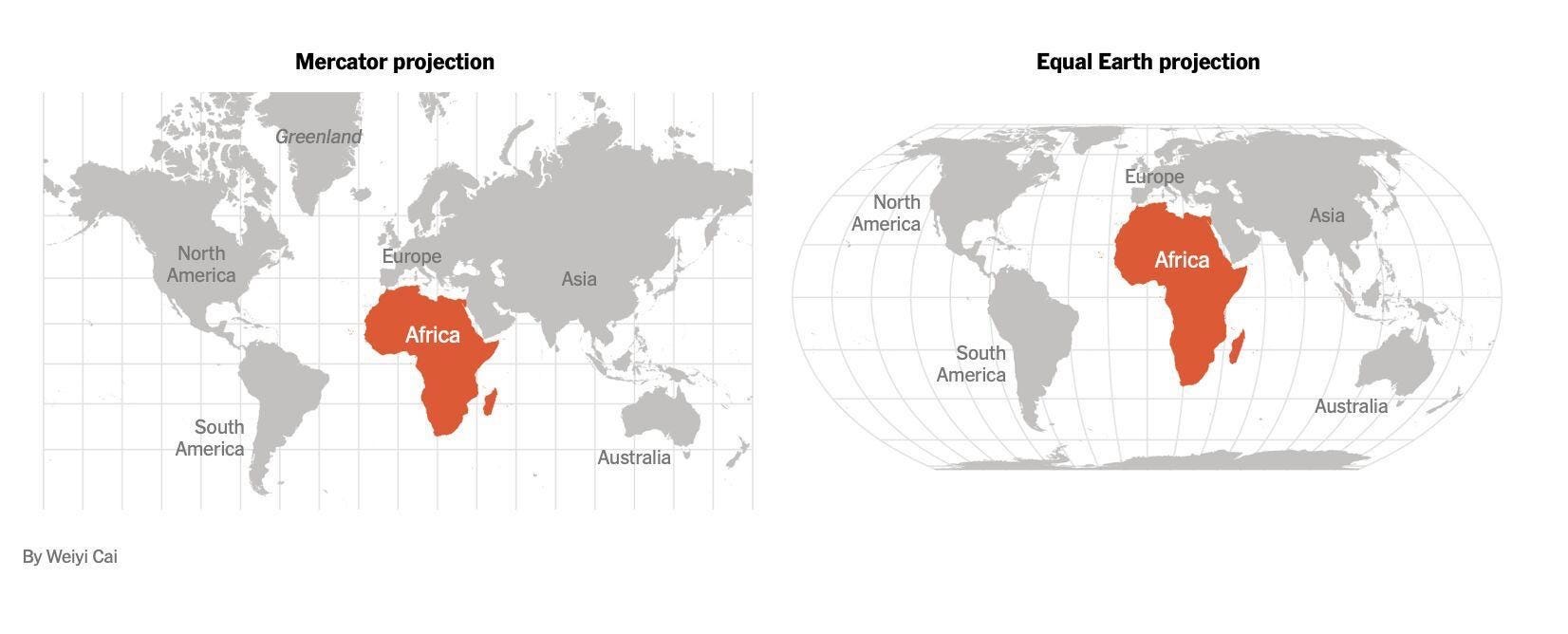
The new map’s supporters say the Mercator projection has contributed to a historical bias that has minimized tropical and equatorial regions and exaggerated the size of countries towards the poles, reinforcing a Eurocentric and colonial worldview. The “Correct the Map” resolution aims to address a colonial-era injustice that has visually shrunk Africa for 450 years, shaping how the continent is perceived in media, education, and policy around the world. For Africa, the significance is therefore less about eliminating an old map and more about changing the visual language through which the world has been taught to understand the continent. In terms of actual size, Africa is larger than all continents except Asia – and is larger even than Asia if the area of Russia is excluded.
Ahead of the vote, France, which co-sponsored the resolution, announced that it planned to abandon the Mercator map. The foreign ministry “will abandon the Mercator projection in favor of map representations tailored to specific uses, more faithful to actual surface areas and in line with the recommendations of cartographers and scientists,” French Foreign Minister Jean-Noel Barrot said.
In the Mercator projection map, “the United States, Russia and China take on a disproportionate visual prominence compared to Africa, Latin America or Southeast Asia,” Barrot said, adding that “distortions eventually take root in perceptions” and that “the time has come to correct them.”
The United States – the only country to vote against the resolution – said it promoted an “ideological agenda” and was a distraction from the “genuine problems of international peace, prosperity or good relations.” In response to this vote, Togolese Foreign Minister, H.E. Prof. Robert Dussey, expressed his respect for the decision of the U.S. and reaffirmed Togo’s willingness to continue dialogue and cooperation between Africa and the U.S., in order to work together for peace in the world.
The movement to "Correct the Map" is about far more than cartography—it's about challenging outdated narratives and recognizing Africa's true scale, influence, and role in shaping our shared future. As the world reexamines how it sees the continent, the American Geographical Society invites you to our annual symposium, Geography 2050: Africa Shaping Tomorrow. You will join leading thinkers, policymakers, and innovators in exploring Africa's growing impact on global development, technology, sustainability, and geopolitics. Be part of the conversation— Join us in NYC this November 19-20, 2026, at the Schomburg Center for Research in Black Culture!
How we represent the Earth shapes how we view the world
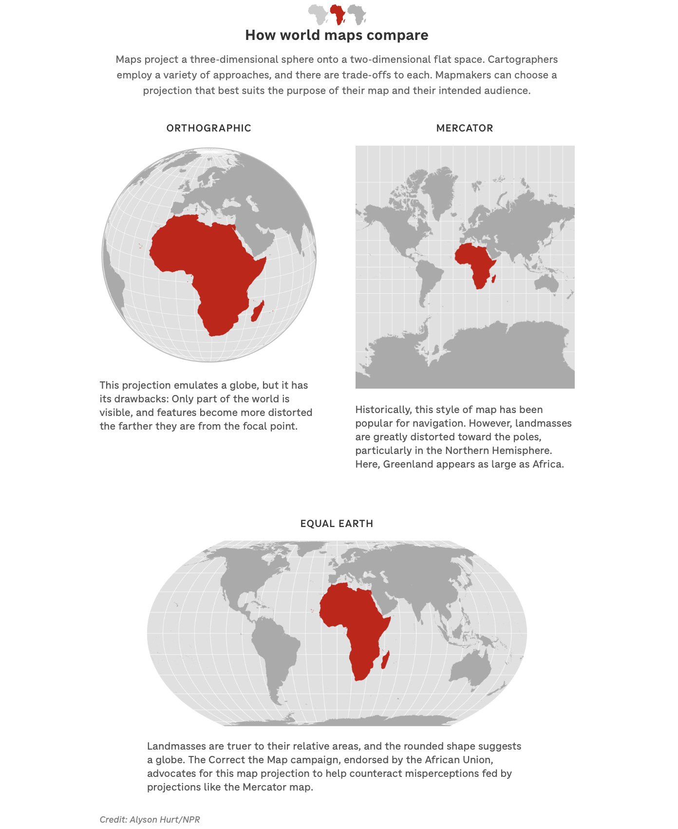
Developed in the 16th century by Flemish cartographer Gerardus Mercator, the projection distorts the relative size of land masses by expanding those nearer the poles. For instance, it makes Greenland appear roughly the same size as Africa, even though Africa is about 14 times larger.
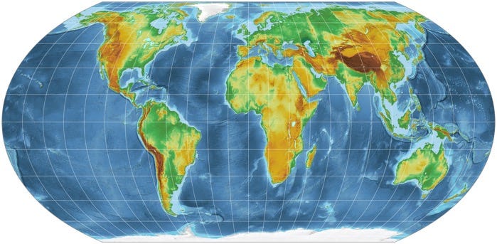
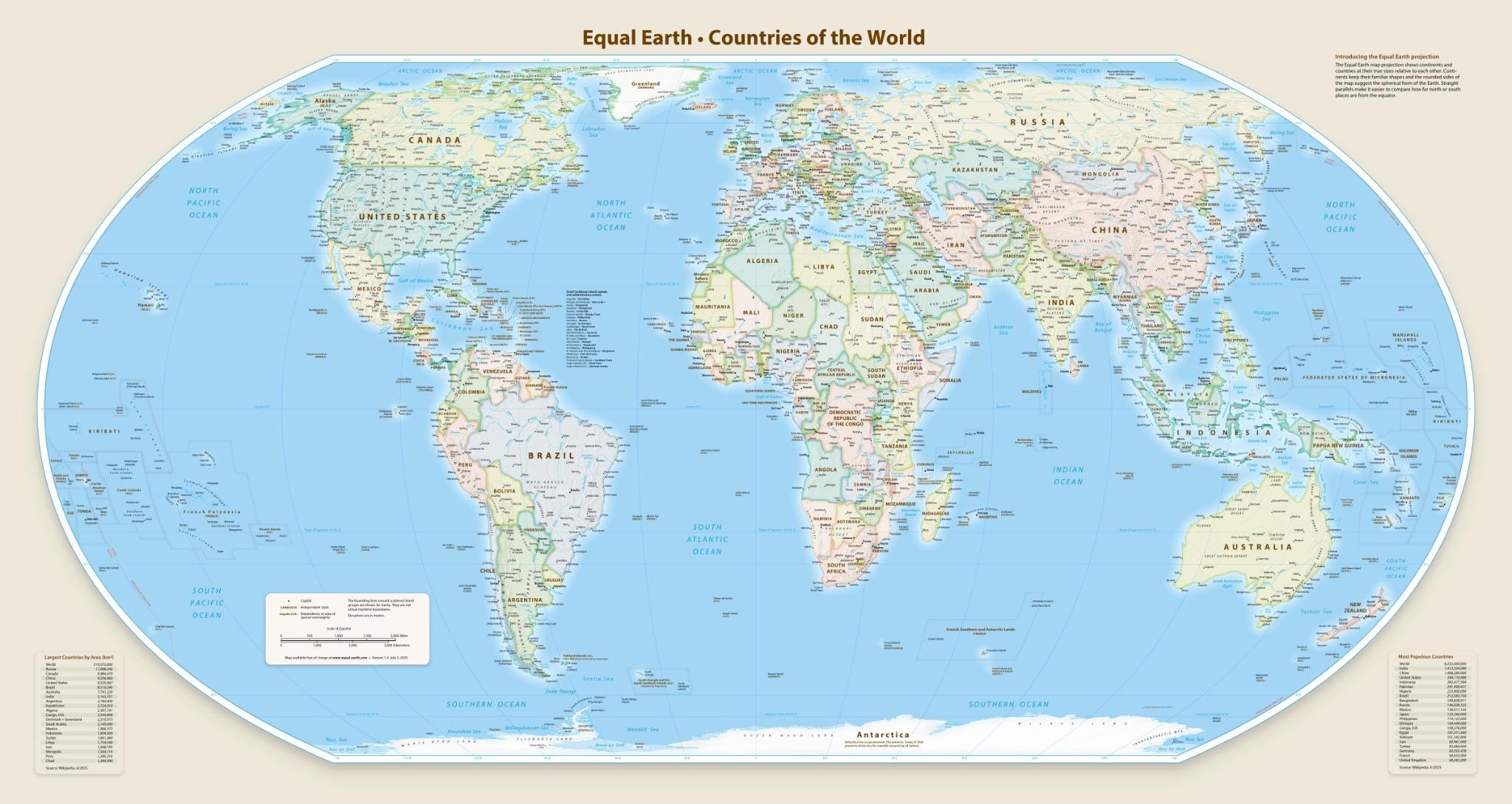
Advocacy groups in Africa have campaigned to replace the Mercator map since April 2025. Togo’s #CorrectTheMap campaign promotes the Equal Earth projection, created in 2018 by the cartographers Bojan Šavrič, Bernhard Jenny and Tom Patterson, to address the distortions found in the Mercator projection and show the relative surface areas of the continents more accurately. The African Union endorsed the campaign in August that year, urging its 55 member states to adopt the Equal Earth map in schools and public communications.
The U.N. resolution does not outlaw the Mercator projection or require the use of the Equal Earth map, and “in no way challenges the use of the Mercator projection for maritime and aerial navigation, for which it remains fully suited,” the Togolese ministry said in a statement. But it is part of a campaign to raise awareness of how visual representations of the Earth shape how people view the world.
‘Distortions eventually take root in perceptions’
Every map projection makes sacrifices, like shape, size, or distance: You can’t flatten a round object without somehow stretching, shrinking, or tearing it. The Mercator projection reflects true directions but distorts the size of landmasses. Equal Earth sacrifices straight-line directions to render landmasses in their correct proportions. It has rounded edges to account for the Earth’s spherical shape instead of a rectangle. Equal Earth is useful for comparing land area, climate, and land use, while Mercator remains useful for navigation.
But in an interview with NPR last year, Tom Patterson, co-developer of the Equal Earth projection and a former senior cartographer at the U.S. National Park Service, said the Mercator projection can create a misleading impression when used as a general-purpose world map. “If you’re using the Mercator map as a world map, say, in the classroom, students would just have a completely warped view of the size of countries in the world,” Patterson said.
“A map is never neutral,” said H.E. Prof. Dussey. “It shapes perceptions, influences how the place of peoples and continents in the world is understood and may, sometimes from the earliest years of schooling, perpetuate representations that do not correspond to geographic reality.”
“Maps shape our understanding of the world,” the global body quoted Dussey before the vote. “They guide education, nourish the imagination, and influence collective perceptions.” Supporters of the Correct the Map campaign say a different projection could help provide a fairer visual representation of the world and challenge longstanding misconceptions about Africa’s size and importance.
A world map which sees Africa accurately
The vote was welcomed by the African Union in a statement on X: “Today’s resolution promotes equal-area maps like Equal Earth across classrooms, media, and international institutions, ensuring the world map finally reflects Africa’s true scale, weight, and place in the world.”
Togolese Foreign Minister H.E. Prof. Dussey linked the campaign to adopt the map to wider African efforts to confront colonial-era legacies, while saying it was not an attack on Europe or any other civilization. The Mercator map’s widespread use is a consequence of colonization, he said. “The world is changing. Africa also is changing.”
Moky Makura, executive director of the advocacy organization Africa No Filter that’s involved in the “Correct the World” map campaign, hailed the vote, saying “now the real work begins.”
The resolution before the U.N. General Assembly calls on the more than 190 member states to update their educational materials and educate students about the accurate sizes of countries and the limitations of different map projections. It also urges major digital map providers to discuss the issue with governments and adopt more accurate cartographic representations.

“If we got something as basic as Africa’s size wrong for this long, what else about Africa have we simply accepted without questioning? Africa doesn’t need to be made bigger. It needs to be seen accurately,” Makura added.
Join the conversation: Geography 2050—Africa Shaping Tomorrow
As conversations about representation, perception, and Africa’s place in the world continue to evolve, these themes will take center stage at the American Geographical Society’s Geography 2050: Africa Shaping Tomorrow symposium on November 19–20, 2026, at the Schomburg Center for Research in Black Culture in New York City. Convening leading scholars, educators, policymakers, business leaders, and innovators, the symposium will explore the forces reshaping Africa’s future—from demographics and urbanization to technology, geopolitics, climate resilience, and cultural influence—and what those transformations mean for the rest of the world.
Join us as we examine how new perspectives – including those around the relative size of the African continent – can help build a more accurate understanding of Africa’s growing role in shaping the twenty-first century.
You can present digital or in-person lightning talks or poster presentations at the conference. To learn more and register, go here: https://www.geography2050.org/.
References
Bright, J. (2026, September 4). The U.N. backs a new world map showing Africa in its true relative size. NPR. https://www.npr.org/2026/09/04/nx-s1-5958611/africa-world-map-un-vote
Ekanem, S. (2026, September 4). Despite US opposition, Africa wins UN backing to correct world map that shrinks its true size. Business Insider Africa. https://africa.businessinsider.com/local/lifestyle/despite-us-opposition-africa-wins-un-backing-to-correct-world-map-that-shrinks-its/18lgwfw
Everett, M. (2026, September 4). UN votes to adopt new world map that reflects Africa’s true size. Al Jazeera. https://www.aljazeera.com/news/2026/9/4/un-votes-to-adopt-new-world-map-that-reflects-africas-true-size
Rédaction Africanews. (2026, September 5). UN General Assembly adopts new world map that shows Africa’s true size. Africanews. https://www.africanews.com/amp/2026/09/05/un-general-assembly-adopts-new-world-map-that-shows-africas-true-size/
Yoon, J. (2026, September 4). U.N. Approves African Proposal for a New World Map. The New York Times. https://www.nytimes.com/2026/09/04/world/africa/world-map-projection-africa.html
Did you enjoy reading this? Support the American Geographical Society today with a donation of $50 to help us support Geography education.

Members of the American Geographical Society enjoy reduced-price access to AGS events and free access to the online version of Geographical Review.


You are invited to our 175th Anniversary globe signing event on September 15th at the Explorers Club in New York City, featuring renowned explorer, oceanographer, and astronaut Dr. Kathy Sullivan. Support the Society’s 175 Campaign with a gift of $175 or more and receive an invitation to this exclusive event, where you’ll have the opportunity to see one of the world’s most extraordinary historical artifacts gain its newest signature. Join us on September 15 as we celebrate the explorers who have shaped our understanding of the world—and help ensure that the spirit of exploration continues to inspire future generations.
Submit Lightning Talk and Exhibition Poster Proposals Today! Speak at our annual fall symposium, Geography 2050: Africa Shaping Tomorrow, taking place this November 19-20, 2026, at the Schomburg Center for Research in Black Culture in New York City! By 2100, over one-third of the world’s population will live in Africa, already the world’s youngest and fastest-growing continent, with profound implications for the interconnected human and environmental dimensions of the transformative demographic and technological boom across Africa. Submit proposals to speak at Geography2050 here!
Our Geography 2050 Trip Planning Page is Up! You can view information about this year’s venue and our partner hotels with Special Symposium Rates. Early birds can register for the lowest ticket price and book their stay at Aloft Harlem or the Renaissance New York Harlem Hotel at this special rate TODAY by going to the Geography 2050 Trip Planning page.