


The AGS Globe: Ghost Networks: The Undercover Threat to Biodiversity
The American Geographical Society's Weekly Newsletter for June 24, 2025

We hope you have enjoyed the first issues of our new weekly, the AGS Globe. The Globe aims to inform and inspire the public with articles about the realms of geography and geospatial as well as exciting opportunities and news from our network. Our pieces fall under four categories: Exploring the World, Championing Geography, Mapping the News, and EthicalGEO. As the world revolves, geography evolves. The mission of the AGS Globe is to bring our storied legacy of exploration and thought leadership into the frontiers of the future.

Ghost Networks: The Undercover Threat to Biodiversity
Read more: Ghost Networks of Illegal Resource Extraction | EthicalGEO
New technologies are helping researchers discover secret ways that people are illegally taking natural resources from the land, sea, and air. These hidden routes, called “ghost paths,” make it easier for illegal logging, fishing, and mining to happen without being detected. Examples include “dark vessels” (untracked ships), “ghost roads” (illegal roads through forests), and “clandestine airstrips” (secret landing sites for planes in remote areas).
In the past, it was difficult to monitor these activities because they cover such large areas and are often hidden from view. But with artificial intelligence (AI) and detailed satellite imagery, scientists can now identify suspicious patterns and track illegal activity more effectively.
While this research is still developing, just being able to identify these hidden operations is a crucial step. It allows governments and environmental groups to better understand and address the threats.
Dark Vessels: Hidden Ships on the Ocean

A study by Global Fishing Watch (GFW), published in the journal Nature, used geospatial AI (GeoAI) to analyze ship activity around the world. They found that about 75% of large fishing vessels aren’t being tracked, and many energy and transport vessels also go unnoticed.
This matters because if we don’t know where and how much people are fishing, we can’t manage ocean life properly. Overfishing has already pushed about one-third of fish populations past safe levels, and industrial activity has destroyed many important marine habitats.
Historically, ships are tracked using a radio system called AIS (Automatic Identification System). But ships that want to stay hidden can just turn this system off. So, researchers used AI to analyze massive amounts of satellite data and GPS records to detect ships that weren't showing up on official systems. The director of GFW called this work “the beginning of a new era in ocean management.”
Ghost Roads: Illegal Roads Through the Rainforest
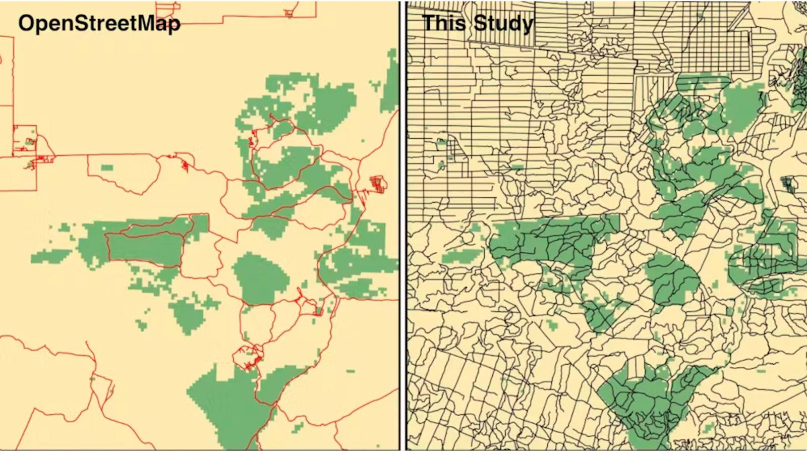
Another study found thousands of hidden roads built in tropical forests, especially in places like Indonesia, Malaysia, and Papua New Guinea. These “ghost roads” are used for illegal logging, poaching, and mining. They don’t show up on official maps, which means they often go unnoticed by authorities.
Using satellite images, volunteers spent over 7,000 hours mapping roads that official databases had missed. This revealed that the real number of roads is far higher than expected.
These roads are dangerous for the environment. They often lead to deforestation and harm to local wildlife. Even protected areas aren't safe, as researchers found that illegal roads can lead to just as much deforestation inside national parks as outside them. To truly protect forests, it's not enough to mark them as “protected.” Authorities also need to prevent roads from being built there in the first place.
Clandestine Airstrips: Secret Flights in the Amazon

In remote parts of the Amazon rainforest, illegal mining operations rely on secret airstrips and unregistered planes to move people and equipment. An investigation found over 1,200 illegal airstrips, including dozens within Indigenous territories like the Yanomami area in Brazil.
These flights are often untraceable because the aircraft turn off their transponders and fly low to avoid radar. Even when authorities shut down an airstrip, mining flights often return soon after.
To track these flights, researchers used a mix of satellite images, public map databases, and AI tools. By looking for signs like forest clearings and muddy pools (used in mining), they were able to identify areas likely connected to illegal operations. To help them determine which airfields were unregistered, they cross-referenced their findings with OpenStreetMap, a community-built global map of roads and infrastructure.
Why This Matters
AI is a powerful tool for identifying illegal environmental activity. It can process huge amounts of satellite data to detect hidden patterns that would take humans years to find. However, it’s not perfect. For example, trained humans are still better than AI at spotting ghost roads in satellite photos, and many flights over the Amazon are still hard to track.
Despite the challenges, technology like this could be essential for the future. Most governments don’t have the resources to monitor every ocean or forest. With the help of AI, they can focus on the most at-risk areas and take action faster.
In the long run, these technologies could help us better understand how illegal activities affect the environment and lead to stronger protections for the planet.
Sources:
Andreoni, Manuela. (2022, August 2). The Illegal Airstrips Bringing Toxic Mining to Brazil’s Indigenous Land. Pulitzer Center.
Laurance, Bill. (2024, April 10). Roads of destruction: we found vast numbers of illegal ‘ghost roads’ used to crack open pristine rainforest. The Conversation.
Potter, Hyury. (2022, October 13). Investigating Rainforest Destruction: Finding Illegal Airstrips With the Help of Machine Learning. Pulitzer Center.
Thorsberg, Christian. (2024, January 21). These Satellite Maps Reveal Rampant Fishing by Untracked ‘Dark Vessels’ in the World’s Oceans. Smithsonian Magazine.
Did you enjoy reading this? Support the American Geographical Society today with a donation of $50 to help us support Geography education.


A new article is up in FOCUS on Geography, our online multimedia journal! Learn more about the climatic zones of Chile from the University of South Carolina’s Dr. Jerry T. Mitchell in Latitude Makes A Difference: North to South Across Chile’s Middle Regions.
REGISTRATION FOR THE FALL SYMPOSIUM IS LIVE! Register now through September 17 for a special Early Registration discount. AGS is gathering innovators and leading voices from business, government, academia, and the non-profit world to share ideas about how artificial intelligence paired with geospatial technology promises to build a brighter future at our 2025 Fall Symposium, GEOGRAPHY 2050: The Future of GeoAI and the Planet, Nov. 20 & 21, 2025, at Columbia University in New York City.
Participate in Geography 2050: Click the links if you’d like to be considered as a contributor with a Lightning Talk or Exhibition Poster.
CALL FOR SUBMISSIONS: FOCUS on Geography
Do you take beautiful photos and videos in the field that you’ve wanted to share with the world? Have you been hoping to tell a story about a place you care for that might shape how we understand geography? Would you like to expand your research’s audience? FOCUS on Geography is looking for your new submission!
FOCUS on Geography is our peer-reviewed, open-access digital journal. Submissions are reviewed on a rolling basis, and for all issues pertaining to the publication of FOCUS on Geography the editors can be contacted at focus@americangeo.org. Detailed submission guidelines are available here.