


The AGS Globe: Hidden Cities: How LIDAR is Remapping the Ancient World
The American Geographical Society's Weekly Newsletter for June 10, 2025

We hope you have enjoyed the first issues of our new weekly, the AGS Globe. The Globe aims to inform and inspire the public with articles about the realms of geography and geospatial as well as exciting opportunities and news from our network. Our pieces fall under four categories: Exploring the World, Championing Geography, Mapping the News, and EthicalGEO. As the world revolves, geography evolves. The mission of the AGS Globe is to bring our storied legacy of exploration and thought leadership into the frontiers of the future.

Hidden Cities: How LiDAR is Remapping the Ancient World
How do we keep discovering ancient cities in the 21st century? It turns out that ruins are often hidden in plain sight: buried under centuries of vegetation, lost in remote jungles, or obscured by modern development.
For decades, finding ruins of ancient civilizations meant cutting through thick forests, trekking across rugged terrain, and hoping to stumble across something. Today, archaeologists can rewrite the map of the past without setting foot on the ground, using LiDAR (Light Detection and Ranging) technology.
LiDAR works similarly to radar or sonar, shooting rapid laser pulses to detect and track objects. Some beams bounce off treetops, others slip through gaps and hit the ground, and sensors record how long each pulse takes to return. When processed, the data forms precise 3D models and maps of the landscape. This means that LiDAR can reveal the shapes of buildings, roads, and even entire cities buried by time.
Although LiDAR is used in industries like agriculture, aviation, and climate research, its impact on archaeology has been especially transformative. For Latin America, LiDAR has allowed researchers to discover ancient ruins long obscured by thick tropical forests.
Nowhere is this clearer than in Mesoamerica, the region stretching from southern Mexico through Central America home to powerful civilizations like the Maya and Aztecs. Long believed to be sparsely populated in ancient times, vast networks of cities and infrastructure have been found in the dense jungle. Some archaeologists thought that “the tropics are where civilizations go to die.” LiDAR is proving them wrong.

In Guatemala’s Maya Biosphere reserve, over 60,000 previously unknown Maya structures were uncovered, including fortresses, canals, and sprawling cities. A week ago, another Mayan city was discovered in Guatemala’s Uxactún park with a 108-foot (33m) tall pyramid. The discovery caused researchers to rethink our understanding of the socio-political structure of the Maya.
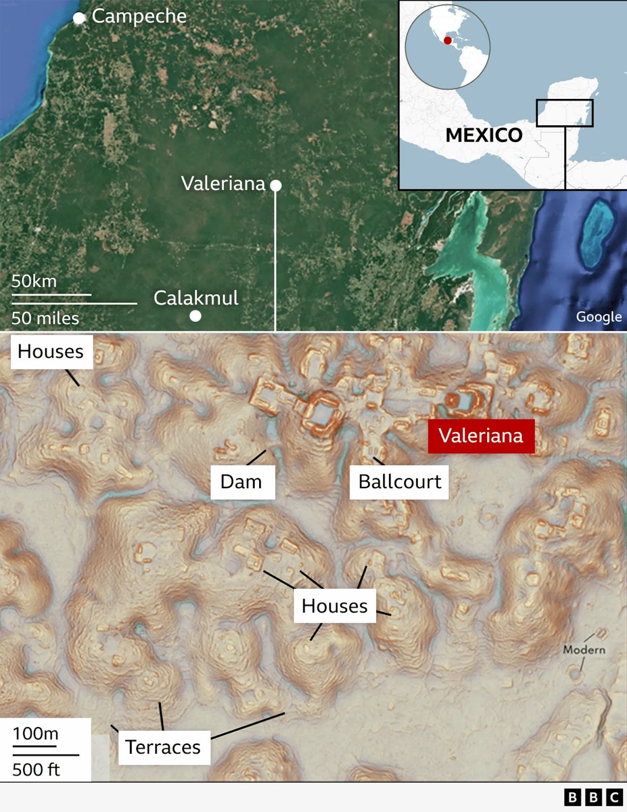
In 2024, researchers announced the discovery of Valeriana, a Mayan city in Mexico’s Campeche state. At its peak in around 750-850 CE, Valeriana may have housed 30,000 - 50,000 people… more than live in the region today! Despite covering more than 6.4 square miles (16.6 sq km), it was hidden just 15 minutes from a main road, shielded by jungle.
However, LiDAR isn’t just transforming our view of Mesoamerica. It has revealed ancient urban networks in the Amazon Basin, challenging the idea that the rainforest has always been sparsely populated. In South Africa, archaeologists unearthed Kweneng, a lost city belonging to the Tswana ethnic group. In Uzbekistan, an ancient Silk Road city, Tugunbulak, was discovered 7,200 feet high in the mountains.
In Mesoamerica alone, LiDAR has mapped 10 times the area in 10 years than archaeologists mapped in 100 years. In fact, more cities have been discovered than researchers think they are able to excavate. These discoveries are rewriting our understanding of how humans have shaped the land— and how much more there is still to uncover. With every LiDAR scan, we’re reminded that the past is still out there, just waiting to be revealed.
Sources:
Rannard, G. (2024, October 28). PhD Student Finds Lost City in Mexico Jungle by Accident. BBC.
Murtha, T. M., Broadbent, E. N., Golden, C., Scherer, A., Schroder, W., Wilkinson, B., & Zambrano, A. A. (2019). Drone-Mounted Lidar Survey of Maya Settlement and Landscape. Latin American Antiquity, 30(3), 630–636.
Fox-Skelly, J. (2024, October 29). Rubber and Tree Sap: How Ancient Maya Cities Have Withstood the Ravages of Time. BBC.
What is Lidar? IBM.
Did you enjoy reading this? Support the American Geographical Society today with a donation of $50 to help us support Geography education.


REGISTRATION FOR THE FALL SYMPOSIUM IS LIVE! Register now through September 17 for a special Early Registration discount. AGS is gathering innovators and leading voices from business, government, academia, and the non-profit world to share ideas about how artificial intelligence paired with geospatial technology promises to build a brighter future at our 2025 Fall Symposium, GEOGRAPHY 2050: The Future of GeoAI and the Planet, Nov. 20 & 21, 2025, at Columbia University in New York City.
Participate in Geography 2050: Click the links if you’d like to be considered as a contributor with a Lightning Talk or Exhibition Poster.
AP Human Geography Teachers! AGS welcomes 50 APHG teachers to the Symposium every year to join as Teacher Fellows, with special teacher-only sessions before and after to help you connect the Symposium discussions to your curriculum, to bring you up-to-date on the latest resources available to enhance your classroom experience, and to give insights on career opportunities for students focusing on the study of geography and geospatial technology. CLICK HERE to apply to join us. Special sponsorship opportunities to help with your travel expenses may be available! If you know an APHG teacher who may not be aware of this opportunity, please pass this along! Applications close Sunday, June 15!