


Welcome to the AGS Globe!
The American Geographical Society's Weekly Newsletter for May 27, 2025

A New Way to Deliver the Best of AGS!
The AGS Globe is our new Substack weekly newsletter. This new channel delivers the same kind of geographical analysis and information as our Map of the Week feature direct to your inbox, along with news and updates about what’s happening at the American Geographical Society.

Stairways to the Sun: Geography of the Inka Realm
We know you’ve heard of the Inka (Inca) empire, but have you ever thought of its geography? The Inka Empire was the largest ancient empire in the Americas, with its center in the towering Andes Mountains. From there, it extended into the dense Amazon rainforest basin, across the high plains of the Altiplano, and all the way to the Pacific Ocean. The Inka civilization began as a small kingdom in the Andes in the early 1200s. Between 1400 to 1533 CE, they expanded through peaceful means and war, to include vast areas of present day Colombia, Ecuador, Peru, Bolivia, Chile, and Argentina.
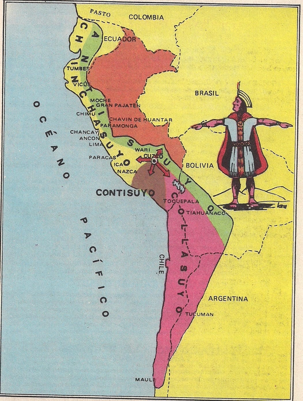
The Inka called their empire Tawantinsuyu, meaning “The Four Regions Together.” These four regions, or suyus, were all connected by a vast and well-built road system called the Qhapaq Ñan, or “royal road.” The capital city, Cuzco, was seen as the center of the world. Roads and sacred sighting lines (called ceques) spread out from Cuzco in all directions to each quarter of the empire:
Antisuyu (east) reached into the upper Amazon rainforest, known for its heavy rainfall, high humidity, and lush vegetation. The Inka sourced coca, medicinal plants, gold, and exotic bird feathers from the Amazon basin.
Chinchaysuyu (north) was the richest farming area, covering much of modern Peru, Ecuador, and parts of Colombia. This region is known for its large valleys, high plateaus, deserts, and canyons.
Contisuyu (west) included coastal land and mountains, offering seafood, steep terrain, and volcanoes.
Collasuyu (south) was a wide, grassy high plain across southern Peru and parts of Bolivia, Argentina, and Chile, ideal for raising llamas and alpacas, and rich in salt, potatoes, and metals like gold and silver.
Despite the challenging geography of mountains, deserts, and jungles, the Inka built a powerful and connected empire. Their biggest engineering achievement was the Qhapaq Ñan: a massive road network stretching 25,000 miles (40,000 km). It included stairs, bridges, drainage systems, and retaining walls. Two main routes ran north to south—one along the coast and one through the mountains.
Even without wheels, the Inka moved goods, messages, and people efficiently through a territory covering 770,000 square miles (2,000,000 sq km). They used llamas and human porters, and messages were delivered quickly by trained runners called chasquis, who could cover nearly 150 miles (240 km) in a single day. The roads also had rest stops for travelers.
At its height, about 40,000 Inka ruled over 12 million people who spoke more than 30 different languages. Today, more than seven million people, mostly Quechua and Aymara, are direct descendants of the Inka. They still live in the Andes, the world’s longest mountain range, carrying on the culture and traditions of one of history’s most impressive civilizations.
Sources
Julien, C. (2009). Inca worldview. Geography and Ethnography: Perceptions of the World in Pre‐Modern Societies, 128-146.
Smithsonian Museum of the American Indian. Geography | The Inka Empire
World History Encyclopedia. Inca Civilization.
Did you enjoy reading this? Support the American Geographical Society today with a donation of $50 to help us support Geography education.


AGS President Emeritus Dr. Jerome “Jerry” Dobson spoke to Wyoming’s Cowboy State Daily about the Most Remote Place in America’s Lower 48.
AGS is gathering innovators and leading voices from business, government, academia, and the non-profit world to share ideas about how artificial intelligence paired with geospatial technology promises to build a brighter future at our 2025 Fall Symposium, GEOGRAPHY 2050: The Future of GeoAI and the Planet, Nov. 20 & 21, 2025, at Columbia University in New York City. Click the links if you’d like to be considered as a contributor with a Lightning Talk or Exhibition Poster.
AP Human Geography Teachers! AGS welcomes 50 APHG teachers to the Symposium every year to join as Teacher Fellows, with special teacher-only sessions before and after to help you connect the Symposium discussions to your curriculum, to bring you up-to-date on the latest resources available to enhance your classroom experience, and to give insights on career opportunities for students focusing on the study of geography and geospatial technology. CLICK HERE to apply to join us. Special sponsorship opportunities to help with your travel expenses may be available! If you know an APHG teacher who may not be aware of this opportunity, please pass this along!